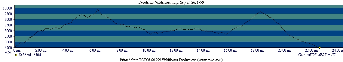
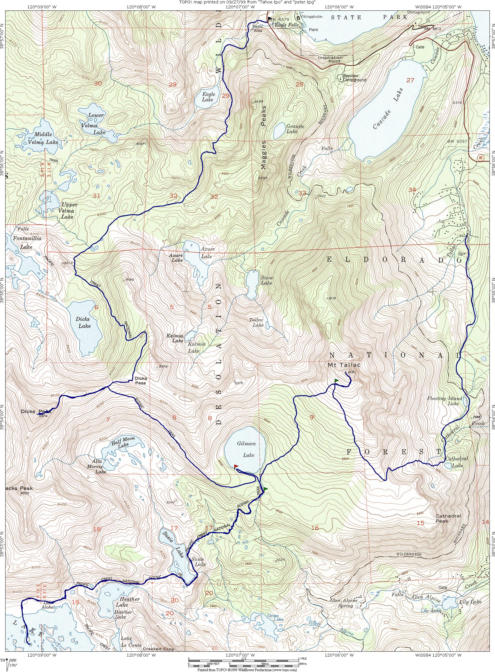
We left the Bay Area on Friday evening and headed to South Lake Tahoe. As expected, traffic was heavy near San Francisco and Oakland, but it was an easy drive after that poing. On Friday night, we stayed at the Fallen Leaf campground, just a few miles north of South Lake Tahoe on HW 89. After a short discussion, we decided that a good night of sleep was more important than an early start, so we set up a wake up time of 7am. Despite this early wake-up time, we didn't break camp until 8:45am. After getting the permit in the ranger station (no quota this time of the year, but still $5 per person per night), we headed to the Desolation Wilderness. The Desolation Wilderness is neither desolated nor wild. We met countless people (and dogs) in this trip. Also, the area is far from being wilderness; trails are very well maintained and signed.
From our trailhead, Eagle Falls (6579ft), we started a steady climb towards the Pacific Crest Trail (PCT). Before joining with the PCT, we broke for lunch at a beautiful lake at 8200+ ft. Our trail joins the PCT at Dicks Lake (8400+ ft), this is a beautiful lake with an incredible peak, Dicks Peak, as a background. We couldn't spend much time there, as everybody was eager to get to Dicks Pass (9160+ ft) and conquer Dicks Peak (9974 ft). The US forest map shows a trail from Dicks Pass to "almost" the top of Dicks Peak (this trail is not in the Tom Harrison's map). However, the trail quickly disappears and the climber is faced with some Class 2 (maybe 2.5?) rocks. From the pass, we follow the trail to the South side of an unnamed peak East of Dicks peak. The trail switchbacks in the East face of the peak until it gets to a sandy gully. Some people follow the gully, but other preferred the solid Class 2 rocks of the East face. After the gully, you climb a ridge on Class 2.5 rocks straight up to a false summit. From the false summit, there is an easy path directly to the real summit. In our group, Carlos, Florian, I-Ching, John, Kristina, Peter, and Arturo made it to the top. After the peak, we went back to Dicks Pass and headed to Gilmore Lake (8320+ ft), where we set up camp for the night.
On Sunday morning, we hiked back to the PCT and drop our packs near the trail. Now, with only our daypacks, we hike to Aloha Lake. This is one of the most spectacular areas I've ever been. The three lakes we visited, Susie Lake (7800+ ft), Heathers Lake (7920+ ft), and Aloha Lake (8160+ ft), are beautiful. The mosquitoes (a problem reported by other people) were not a problem this time of the year, so we were able to enjoy time at the shore of the lakes. Aloha lake (our lunch spot) was specially beautiful. The lake has many small islands, and the water level was low enough, that we were able to walk (without getting much wet) from island to island until we were at the middle of the lake. The place was so beautiful, that Peter had a hard time getting the group moving again. When we finally started to move, we retraced our steps until we got the place where we dropped our packs. Then, we left the PCT and started hiking the Mt. Tallac trail. The climb to Mt. Tallac is not that long, but the trail climbs straight up. The trail ends just 0.2mi from the top of Mt. Tallac (9735ft), which was an easy walk that everybody in our group did. The view from the summit of Mt. Tallac was spectacular: we saw Lake Tahoe and its Nevada casinos; we could also see much of the Desolation Wilderness and its beautiful peaks and lakes.
From Mt. Tallac, there was nowhere to go but down. The trail was
steep and rocky, and I wouldn't recommend climbing to Mt. Tallac via this
way. We passed two lakes: Cathedral Lake and Floating Island Lake;
but people were so eager to get back to the cars (and have dinner) that
we didn't spend much time in them. We finally arrived to the Mt.
Tallac trailhead, where we had one of our cars waiting for us (we shuttle
before the trip). After discussing the merits of fast foods vs. slow
food from car to car using Peter's walkie talkie, we ended eating in a
chain dinner in Placerville. This was a very nice backpacking trip.
|
 |